
 What Is A Watershed?
 The term "watershed" describes a catchment basin that conveys all surface and groundwater that falls within it and runs through it. It is geographically defined by the highest ridgelines, or watershed divides, that encircle it. It is these watershed divides that differentiate it from the adjacent watershed.
The word watershed is used to describe basins, catchments or drainages of varying sizes. For example, The WATER Institute is located in the headwaters of Dutch Bill Watershed, an 11 square mile area nested within its larger watershed, the 1480 square mile Russian River basin. Watersheds can be as small as the property you live on or as large as the Mississippi basin which drains 40% of the North American continent.
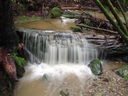
It is common for people to focus on the creek, or river, alone when, in fact, it is everything that occurs from the ridgeline to the rivermouth that makes up the watershed. The movement of water over and through the living ecosystem connects us to one another and to all species living in our Basin of Relation. The quality and quantity of this precious liquid, can determine which and how many of each species can sustainably live in each watershed. The better we understand the relationship between our actions and the watershed we live in, the more likely we are to ensure water security for all species that share a watershed.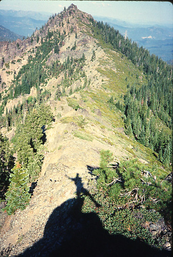
© 2006-2008 by The WATER Institute, Occidental Arts and Ecology Center,
All Rights Reserved
15290 Coleman Valley Road, Occidental, CA 95465
(707) 874-1557 x 206
waterinstitute@oaec.org
- Name of EventOct 18, 2008 - 4:30 pm
- Name of EventDec 5, 2008 - 10:00 am
Water Consciousness Book - Brock contributes a chapter to this newly published guide.
Permaculture: A Quiet Revolution DVD - See Brock interviewed in this new documentary.
Basins Of Relations Publication - Get a copy of our 20 page citizen's guide to protecting and restoring your watershed.
Roofwater Harvesting Resource List - Check out this comprehensive resource on rainwater harvesting policy, design and installation.
 |
In 2004 the Occidental Arts and Ecology Center (OAEC) established the WATER Institute (Watershed Advocacy, Training, Education, & Research) to promote understanding of the importance of healthy watersheds to healthy communities. Building upon OAEC’s many years of work to protect Coastal California’s watersheds, the WATER Institute concentrates on four interrelated and equally strong program components: advocacy and policy development; training and support; education and demonstration; and research.
The WATER Institute staff includes Director Brock Dolman, Associate Director Kate Lundquist, Research Director Jim Coleman and Salmon Safe Pesticide Coordinator Viviana Coloma.
The WATER Institute continues to publish and educate about “Conservation Hydrology,” an applied science being pioneered by OAEC and characterized by the following key concepts:
• Human development decisions must be based on a new “rehydration model” instead of the current “dehydration model.”
• All development must safeguard the health of watersheds and the availability of clean water.
• Land-use management strategies must thoroughly analyze the impact of human activities on the hydrologic cycle, and how these activities affect species, community and ecosystem dynamics.
• Democratic, regionally controlled decision-making processes are essential for the protection of vigorous ecosystems and diverse, resilient hydrological systems.
At local, regional and global levels, we hear ever-increasing demands for ample supplies of high quality water. In response, we must develop accurate means of evaluating the amount of water available for both human appropriation and for the needs of all other life forms and ecosystems. We must defend the perspective that water is common to us all, and we must oppose its privatization.
Asserting that it is “better to be safe than thirsty,” the WATER Institute advocates the use of the Precautionary Principle in decisions about water-use policy. The burden of proof must be on water users to show that their proposed use of our common water can be sustained without damage to the hydrologic cycle. For example, will the new water use adversely affect the infiltration, runoff, creek flows, evaporation, precipitation, condensation, availability, or purity of local water?
This monitoring will provide data to develop an OAEC “water budget,” and will help determine our long-term conservation hydrology plan. For instance, a conservation hydrology strategy for OAEC might include increasing the recharge of our groundwater and enhancing potable water quality by slowing surface water runoff and increasing infiltration. This research will be useful as a model for larger projects in the Dutch Bill Creek Watershed and the Russian River Basin. Numerous water policy and educational opportunities will likely flow from this baseline research.
No comments:
Post a Comment